Estrela's African Land Adventure Journal
Day 41. July 11, 2008. Magoebaskloof Hiking Trail to Magoebaskloof, Limpopo Province, South Africa. Overnight stay (in a rondavel!!) at Magoebaskloof Ruskamp. (23º51.844’S 030º00.512’E). Elevation: 1194 meters
(3917 feet).
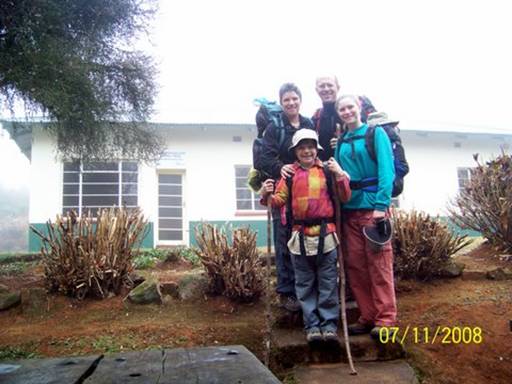
We woke up at Broederstroom Hut to a sky white with fog and the hiking clothes we'd left out to dry completely soaked, along with our firewood.
But luckily it was our last day, and we had extra wood and clothes. It sure was chilly (Pic 1).
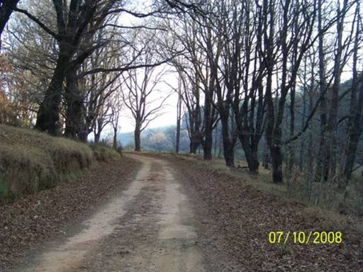
At 8:00 we said goodbye to Selina the caretaker at Broederstroom Hut and walked down a forestry lane (Pic 2),

which, with all the gnarled oaks lining the way, could have been an old road in Woodstock, CT in late autumn. It looked totally different from when we had taken a picture of the same spot yesterday, when it was still sunny (Pic 3).
On we trudged, trying to avoid the tall, wet grass in the road, and struggling to keep our fingers warm. Mom and I just tucked our hands underneath our backpack straps, but since Abby and Dad had hiking sticks to hold onto, their fingers were moving about through the cold air, and so they were freezing. I think sticks are a huge nuisance sometimes, especially when walking steeply uphill; they always are in the way. Abby spent half the time dragging hers behind her. Her excuse was that it actually helped with balancing. Yeah, right.
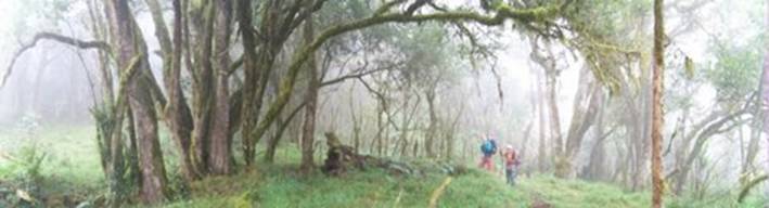
Most of the day we hiked through the indigenous forest, and in the mist it was even more mysterious than before. Giant tendrils of moss hung from wizened trees and the gloomy light barely touched the carpets of ferns (Pic 5).
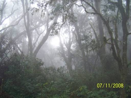
It seemed like the perfect place for a gnome or a fairy. I think an accurate description for it would be a cloud forest, because it never truly rained, it was just drizzly and misty (Pic 4).
The indigenous forest was disrupted by sections of pine plantations.
Actually the truth is that it was pine plantations disrupted by sections of indigenous forest, but they set up the trails so you walk curving around through mostly indigenous forest, skipping from one ribbon to the next. The pines were a break from the closeness and tangle of the ancient forest. The horizon opened up and we could see quite far between the neat rows. Most of the time the trails through the plantations were old disused logging roads, and it was lovely not to keep tripping over roots and fallen branches. But then I'd remember how this whole place was once indigenous forest, and they'd cut it down, all the animals' homes and the ancient hard woods, to make these pine and blue gum plantations for paper and building materials and other things. We would walk into clear-cut hillsides where the pines had already been taken away to a mill somewhere, and it looked so ugly and sad, like the soul of the land had been taken away as well, but not only because the pines were gone.
Halfway to the end, we were about to cross yet another drainage when Mom spotted an orange peel on the trail. It's amazing to me how careless some people are with their orange peels, especially since if it takes them 60 years to decompose in the ocean, it must take a long time on land, too (I don't know how long). Anyway, Mom put the peel in a bag and we carried on around the bend. A huge group of orange-eaters must have decided to use this section of the trail as a lunch stop because the ground on both sides was littered with little pieces of orange peels. I was really mad. We split up and gathered every scrap we could find, dumping it all in the garbage-collecting bag attached to the back of Mom's pack. The bag was very large by the end, and I don't know if we even got all the bits of peel, but at least the trail will look better for the next hiking group that comes along.
Dad's stick, Twig of Power, fell in the Dokolewa River five minutes away from Dokolewa Pools Hut, and a half hour from the car. Twig saved Dad from falling into a particularly good swimming hole we had walked closer to stare at longingly. Okay, so maybe sticks are good for something.
We climbed the last, steep hill up to De Hoek Hut, knowing that each agonizing step brought us a little closer to the end. Then we saw the red painted building and our beige car waiting for us. WE MADE IT!!!!!!!
Exchanging sweaty clothes for warm ones, we sat at the picnic table for hot drinks and crackers. The whole 18 km we'd hiked today we hadn't stopped for any food or water breaks, because it was too cold and we had so far to travel. So we all really needed this rest. Elated and exhausted and frozen, we decided to stay at the Magoebaskloof Ruskamp again because we had no idea where we were going next, it was getting dark, and we were all freezing. Thankfully Mom and Dad asked for a rondavel, instead of a campsite like last time, which meant we didn't have to do anything to get it set up, we didn't have to have a cooking braai because there was a little kitchen inside, and there was a TV (we watched James Bond's "On Her Majesty's Secret Service").
I love hiking and I can't wait to do more. This trail, the Magoebaskloof Hiking Trail (see website: www.komatiecotourism.co.za), was one of my favorites so far. I'll always remember hiking through the different types of forests and carrying everything we needed on our backs. We're thinking of maybe going hiking in the desert in western Namibia in a few weeks and also in the Outeniqua Mountains after we get back to Knysna. I'm really excited.

-- Eliza
Days 42-43. July 12-13, 2008. Magoebaskloof, Limpopo Province, South Africa. Overnight stay at Magoebaskloof Ruskamp. (23º51.844’S 030º00.512’E). Elevation: 1194 meters (3917 feet).
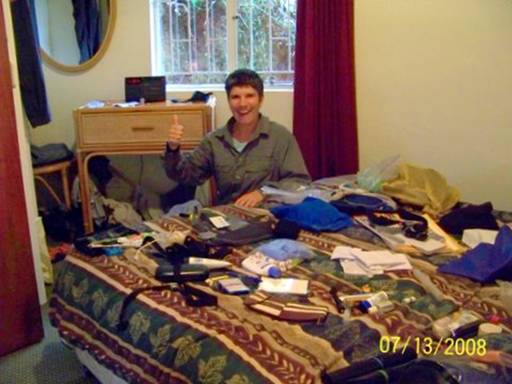
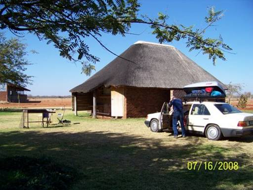
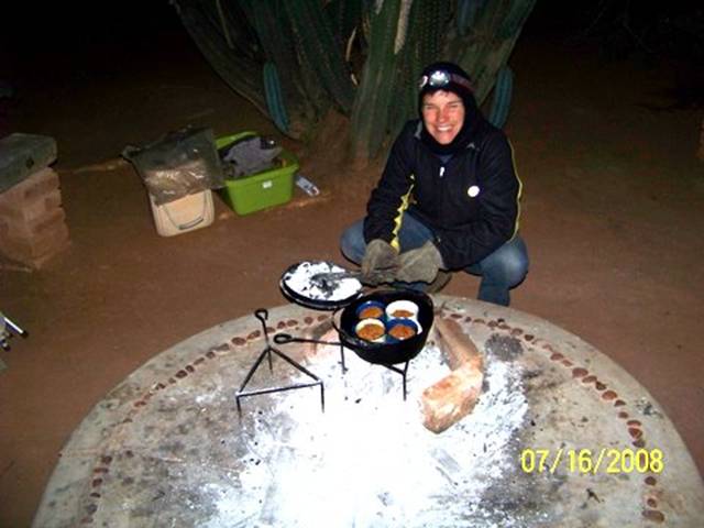
Very thankful to be off the trail, we awoke to an even gloomier and chillier day on the 12th and low clouds and misty rain hung on for two more days. We had all been chilled to the bone on that long last hike and couldn't seem to warm up. Then Eliza came down with a fever. No question that we'd just stay put in the rondavel (Pic 1).
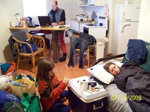
Our bodies wanted healing and all our gear needed to be emptied, cleaned, shuffled and repacked (Pic 2).
We had to make the transition from hiking-camping back to car-camping. So we enjoyed a few days of conventional living with an indoor kitchen, electricity (except for the few hours that it went out during dinner prep on the 13th when I wished that I had cooked over the fire!), and (by the second day) a space heater. We finally recuperated.
-- Kyle
Day 44. July 14, 2008. Magoebaskloof to Polokwane, Limpopo Province, South Africa. Camping at Polokwane Game Reserve Caravan Park. (23º53’S 029º27’E).
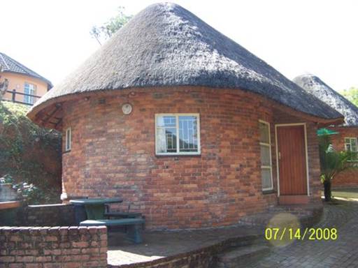
Pic 1: The rondavel, our sanctuary during the cold weather. We learned this morning we'd been the only guests last night in the whole Magoebaskloof Ruskamp! Notice the sunshine, which finally returned. Ahhhhhh . . .
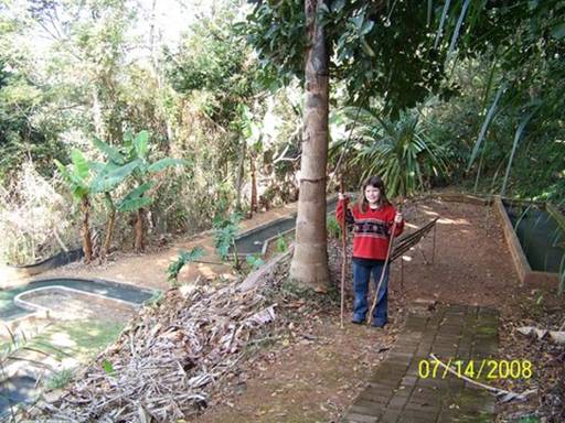
Pic 2: Abby bids goodbye to Lightning Bolt and the baboon spear we had carried all the way from Royal Natal. She had a few minutes alone with them before leaving them propped against a tree.
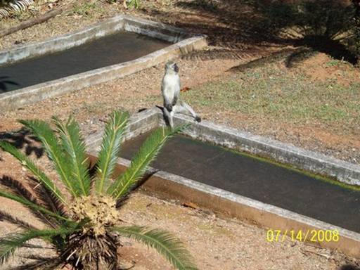
Pic 3: A typical African campground scene -- a vervet monkey somewhere in the background -- this one perched on the put-put course.
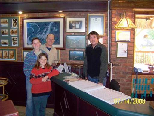
Pic 4: Checking out of the Ruskamp and saying goodbye to our new friend Etienne, the manager.
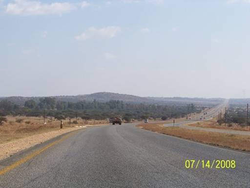
Pic 5: Back to arid roadside scenery. Heading west, we crossed a pass and left the hills and fertile, lush farm land behind. I think we'll be seeing a lot of this all the way through Botswana -- flat and dusty.
-- Kyle
Day 45. July 15, 2008. Polokwane to Grobler’s Bridge, Limpopo Province, South Africa. Camping at Big Fig Inn. (23º01.433’S 027º57.737’E).
Elevation: 779 meters (2556 feet).
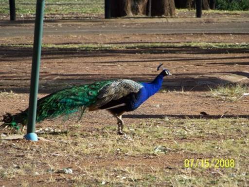
Waking up at the Polokwane Game Reserve campground we all felt energized and excited to be nearing the Botswana border. We had shaken off the nervous reservations we'd felt arriving at dusk the evening before. Yes the place was run-down, some broken windows gaping and many of the electrical boxes dead. But we had figured out the scene and felt safe. The bathrooms were dowdy but spacious and clean; they even had big bathtubs. This was surely no tourist spot. Groups of workers had arrived at dusk, setting up heavy staked canvas tents, cooking dinner on fires and portable hot plates, and going right to sleep, and then had packed and left well before we emerged from our tent. As we lingered over breakfast, warming our hands on coffee and cocoa mugs (Pic 1)
we watched the peacocks and peahens (Pic 2)
and braced for the big push to break camp, load the car, and drive to Grobler's Bridge, on the Botswana border.
Then we had one of those travelers' encounters that might have come to nothing more than an exchange of smiles and kind words and a memory of warm curiosity about a conversation or even a friendship that might have been.
But something led us to talk a little bit longer with the gentle young mother slowly walking her two busy toddlers crookedly around the campground, collecting peacock feathers and other treasures off the ground.
The story we heard from her and from her own mother who walked over after a while to check up on her errant family left us deeply moved. This was a family on the brink. It was the Will Smith movie, "The Pursuit of Happiness" come to life. Six of them were traveling, virtually living, in their compact car. The night before was the first in three days they had been able to afford the modest campground tenting fee. They had spent the coins they had collected from passersby to pay the camp fee, instead of to buy petrol to continue driving south, so the babies could get washed up.
They were refugees from Zimbabwe, their large game farm having been taken from them at gunpoint, with one hour to pack, two years before. The father had had his family wait for him at the farm gate while he returned to walk back through the house and barn to lovingly shoot their horses, dogs and tame cheetah. He knew from the stories told him by other farmers that his animals would have starved or have been slaughtered inhumanely.
Then their attempt to make a go of things in town hadn't worked out. The father was now terribly ill with a brain tumor and the recent political chaos had left them all deeply frustrated and fearful for their lives. They had lost dear friends, white and black, to the violence. Recently the mother and father had traveled to South Africa to make arrangements to emigrate, lining up a job sponsor and medical care. The father was determined to see his family safely resettled.
A few days before we met them, the parents and their daughter and her husband, with their two little ones, had packed up what they could carry and headed for South Africa. Five minutes before reaching the border, which was only a few hours north of Polokwane, they had had a flat. While changing the tire they were robbed by a group of young men with guns. They lost passports, wedding rings, all their cash and jewelry, even the medication the father needed for seizures and pain. They would have lost the car but the spare too was flat.
They had their lives, though, and spirits and hope like we could not imagine. And they still love their country, Zimbabwe. We heard stories of life there and of how beautiful and prosperous the country had been. If peace and security were restored they'd return in a heart beat. Kyle and I were so moved talking with them. The mother had a smile and sense of humor that we could see were sustaining this family. What strength. What love and faith. We helped them with some food and a loan of money toward their petrol costs. They'll be back on their feet again soon and we hope to visit them in a few months when they're settled in a new home further south.
There but for the grace of God go I? . . . it sure felt that way for us this morning.
-- Doug
Day 46. July 16, 2008. Grobler’s Bridge, Limpopo Province, South Africa to Palapye, Botswana. Camping at Camp Itumela. (22º33.597’S 027º07.706’E).
Elevation: 909 meters (2982 feet).
Sue on Ocelot had told us we'd find camping at the Big Fig Inn, a few kilometers before the Botswana border. Our guide books, which include "Lonely Planet Southern Africa," "Coast to Coast" (a southern African guide to "backpackers" accommodations), and "WWW.CaravanParks.com South Africa,"
have thin coverage in the areas we're traveling through now. Word of mouth recommendations for routes, camping spots, and places to explore will be crucial until we are well south again.
What a haven we found here at Big Fig. Continuing one of the unexpected themes of this road trip, we were the only guests. And we could pitch our tent on lush green grass! Everywhere around was dusty, red dirt but the little camping area the Big Fig kept watered for a few tents and caravans (Pic 1).
Abby created a race course around trees, pestering us to time her.
Then she begged each of us to wrestle. There's something about grass like this that makes you just want to roll around. Our host, Vemsby, checked up on us several times and even lent us an electric iron to press an iron-on patch on my therma-rest pad, which had sprung a leak.
We had another very chilly sleep; it's been near or below freezing almost every night. But our sleep systems are working. Though we all wake up now and then when a bag shifts and a cold draft sneaks in or a pad slips and a limb gets stiff and cold, we've all slept well.
The Limpopo River forms the border here between South Africa and Botswana.
We crossed it on a one-lane bridge (Pic 2).

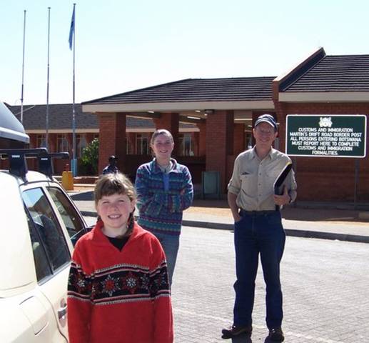
Customs and Immigration check-ins went smoothly on both sides (Pic 3).
We stopped at the first town to change some Rand for Botswanan Pula and to buy airtime for the Botswana "Orange" sim card Sue and John had mailed us to use in our cell phone.
Crossing the border we are losing the cell phone-based internet connection that has let us handle email in South Africa directly from our laptop.
We'll start looking for internet cafes in Botswana where we can plug in our computer.
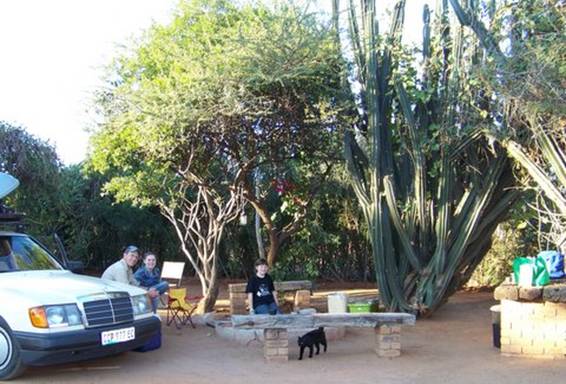
The first big town we reached was Palapye, home of Camp Itumela, a backpackers and camping place with amazing landscaping; friendly dogs, cats, and owners (with kids!); and a well-deserved "warmly recommended" rating in Lonely Planet. There was hardly anyone here and we roamed all over before choosing just the right spot. We pitched our tent in the shadows of enormous clumps of cactus and hedges of an unusual plant with chlorophyll-filled green twigs and branches (Pic 4).
Our campsite's center was an eight-inch high circular concrete cooking slab with an outer ring of imbedded red stones. Kyle produced a delicious treat after dinner carrot muffins baked in the cast iron potjie pot in our tin and ceramic mugs (Pic 5).
-- Doug
Day 47-49. July 17-19, 2008. Palapye, Botswana. Camping at Camp Itumela.
(22º33.597’S 027º07.706’E). Elevation: 909 meters (2982 feet).
After we spent the first day at Camp Itumela only journaling, we thought the rest of our stay here would be pleasant, enhanced by the lovely roofless, outdoor showers and toilets (surrounded by cacti), but like all the other places we’d stayed at to write web logs, just a quiet haven. But we were so wrong. The next day when Abby and I had just pulled out our math books and journals, Simon, the owner of Camp Itumela, came by with the two girls we’d seen playing with some other kids in a vacant campsite the previous day, and introduced them as Danielle, his eleven-year-old step-daughter, and her friend Jenna. “Why don’t you show Eliza and Abigail around the camp?” the adults said. That was the end of school!
In about fifteen minutes we were running wildly all through Itumela with Jenna, Danielle, and their younger siblings as though we’d known them our whole lives. For two days Abby and I had the best time playing games both indoors and outdoors, roasting marshmallows (and sticks!), and even baking a cake. It was just so nice to hang around other kids (Pics 1&2)
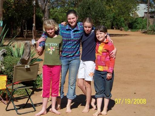
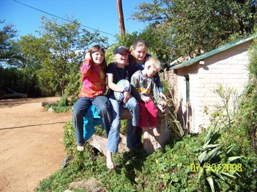
after about a month of being alone together.
-- Eliza
Day 50. July 20, 2008. Palapye to Nata, Botswana. Camping at Nata Lodge.
(20º12.9’S 026º11.2’E). Elevation: 918 meters (3012 feet).
We said goodbye to our kid friends (and their parents, Sue and Simon) and headed north on Botswana's main road, which runs the length of the country from the capital Gaborone, in the far south, to Kasane, in the northeast corner. Kasane lies on south bank of the Chobe River, a few kilometers from where the borders of Zambia, Namibia, Zimbabwe, and Botswana meet at the confluence of the Chobe and Zambezi Rivers. By late afternoon we reached Nata, about half-way to Kasane, and found a sandy, quiet campsite at the Nata Lodge.
This is one of the few paved roads in the country -- two lanes and usually no shoulder. Lonely Planet calls Botswana, which is the size of France and has a population of 1.6 million people, a "largely road-less wilderness of vast spaces -- savanna, desert, wetlands, salt pans and myriad traditional villages." Because we skipped most of the more urban and populated southeastern strip near South Africa, this description has matched our experience.
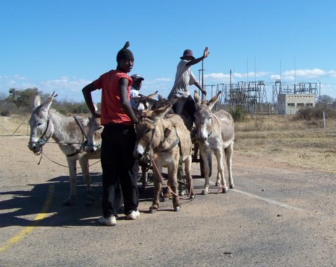
I know this may sound ridiculous, but Botswana seems very "African." The small towns are filled with people buying and selling things in makeshift road-side markets, walking beside the road, sitting in front of stores, and giving us open friendly waves as we pass by. And domestic animals are everywhere. We marveled at the goats walking through the center of Palapye
-- even grazing on tufts of grass beside the Shell gas station; the herds of cattle crossing the main paved road to reach more scrubby, dry grazing land; the sickly, thin homeless dogs patiently waiting outside grocery stores for the chance of a small morsel of food being tossed their way; and the many donkeys, who seem to be the second best type of transportation in Botswana.
I was desperate to capture this foreign land with our camera and yet I was conscious of peoples' privacy and sense of dignity. I always feel a little funny about taking pictures without asking, especially of people just living their lives. So I tried to snap shots surreptitiously, while Doug kept driving. The results were not always the best, but I think these three
pictures capture some of the roadside life we saw in Botswana.
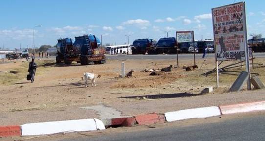

-- Kyle
Copyright © 2003-2009 Doug and Kyle Hopkins. All rights reserved.